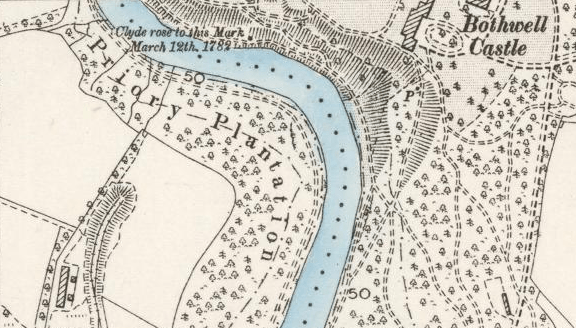
 Intrigued by an overlaid note on a Blantyre 1897 map I recently uncovered some conclusive evidence of a great Blantyre flood of the River Clyde. On my 1897 map, there’s a note against the Blantyre Priory (directly opposite Bothwell Castle) saying “Clyde rose to this mark 12th March 1782“. Capturing my curiosity, I wanted to know more.
So in the spirit of The Blantyre Project, I decided to investigate more in depth and contacted the Weather Met office asking what happened in that particular week, the reply coming back nothing much, which was not eventful and I had filed it away. Weird.
Then, recently I noticed this photo by Karen Madden, which shows a stone engraving on the site but with a different date of 1785, not 1782. Was the map wrong? Indeed it WAS!

Back to weather records again, which are very general for Lanarkshire, rather than specific for Blantyre, but their reply tells of “A cold spell fiercely drove in through Central Scotland on 10th March 1785. By the 11th snow had started to fall and it continued to fall heavy the likes of never seen before for a period of over 12 constant hours. With persons housebound, the great fall of snow ended late evening on the 11th and temperatures immediately started rising again, sharply. By the 12th, rivers and lochs were full of meltwater.” This old Met office account corresponds directly to what was witnessed as an important event which saw the River rise to the point where the paths several metres above the normal River line were covered. The draughtsman designing these Victorian maps felt it necessary to record that historical event on their “modern map” but were careless with the date!
This was an important year for the River Clyde, because further upstream, David Dale had already started building his 1785 Cotton Mill. With a population of only around 500 people at the time, I can imagine the people in Blantyre’s tiny hamlets, huddled around their stoves unable to go outside in such deep snow.
On social media: