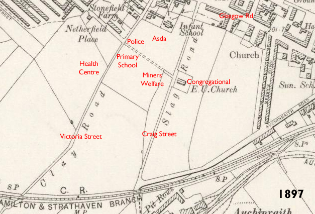
 During the late 1890’s, Blantyre was still going though rapid population growth due to the coalfields. At this time, upgrading the town’s narrow paths and thoroughfare’s was important reinforcing the infrastructure. In this 1897 map of Low Blantyre two tracks were due to be upgraded. Clay Road was a long path that linked Glasgow Road to High Blantyre Main Street. It was essentially a route over fields, with no buildings at any side. Likely to have simply had the topsoil and turf taken off, this was a rough path offering the residents of Blantyre a shortcut from High to Low Blantyre. Shortly after this map was published, Clay road was widened and constructed over forming what is now Victoria Street. A section of the original Clay Road still exists today at the very top of Victoria Street at the junction of High Blantyre Main Street. The road today significantly narrows back to the size it was then which was not much larger than the width of a horse and cart. It is the reason that cars cannot exit off Victoria Street directly on to Main Street. Victoria Street was likely named so, following the death of the Monarch Queen Victoria in 1901, coinciding with a new century.
Running parallel across the 1897 fields, again with no houses was the Slag Road. I’m sure you’ll be relieved to know the slag refers to the slag and ash from the local Auchinraith colliery. The slag was laid down during the coal boom decade of 1880s to form a narrow path running down from Main Street via Auchinraith road , connecting Glasgow Road. Around the turn of the century, the slag road dropped it’s industrial nasty sounding title, was widened and renamed Craig Street after the local landowner. The construction of the 2 roads allowed public buildings to be lined alongside like the police station, Calder Street School and the health centre, although all 3 of those buildings came a couple of decades later.
The attached extract from the 1897 map shows the Clay and Slag Roads and ive overlaid some modern references in red to put the location in context.
Hi Caroline. Elm Street is now where Merry’s Rows once stood. This Miners row of houses is actually marked on the old map in this post. If you click on the map you can see a larger version. It’s the street running up and down the way , (North to South) at the right hand side.
Looking at the wee map above can you confirm that Merry’s Rows was where Elm St is just now?